Category Archives: Wild landscapes

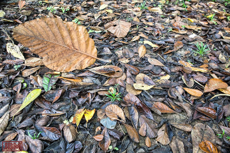
Forest floor

I spend a lot of time at the Kebun Raya Balikpapan looking upwards, craning my neck to see birds, monkeys, fruit, flowers and treetops in the forest canopy.

But the ground below is sometimes uneven, and very often slippery, so I also spend a lot of time looking down at the forest floor. Sometimes that view is every bit as interesting!

Future Landscapes: The South East Coastal Adaptation Project

Some new work. I’ve just completed work on series of images as part of a project with the ANU School of Art ‘Environment Studio‘. The project, which is continuing, involves around 25 artists from across all of the School’s workshops (e.g. painting, sculpture, printing, woodwork, glass – AND photography). Each artist is to create works inspired or informed by the issue of climate change and its future impact on the small communities of south-eastern Australia (from Wollongong, NSW through to Lakes Entrance in Victoria).

This art project is conducted as an adjunct to a bigger project – ‘South East Coastal Adaptation’ (SECA) – which is funded through the National Climate Change Adaptation Research Facility. Here’s how they describe their project in their final report:

“Coastal Urban Climate Futures in South East Australia from Wollongong to Lakes Entrance is an investigation into possible coastal urban futures to 2030 and beyond. The study focus is on coastal adaptation in the context of climate change. It is broad in its scope by considering environmental, social and economic change in the south east coastal region. It has a multi-disciplinary approach to the spatial and temporal dimension in considering action on the ground. It involves seven local government areas (Wollongong, Shellharbour, Kiama, Shoalhaven, Eurobodalla, Bega and East Gippsland), two states and several regional organisations and explores some of the critical governance issues.”

Anyway that’s all by way of background. It’s a worthy, rigorous and invaluable study. But the important thing (at least from the point of view of this blog post) is the art – and specifically. my own photographs.

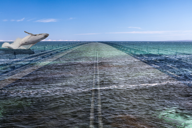
Humpback flight

Humpback flight (2013)

Living in Canberra, I spend a bit of time down in the coastal region covered by the study, making photographs.  Earlier this year I also participated in two field trips down to the area from Merimbula to Mallacoota, exploring towns, national parks and forestry roads, eventually returning home with around 1400 photographs.

I selected a number of images for processing, some compositing of images, overlaying of text etc, and ended up with a couple of dozen final images that I’m pretty happy with. You can see the full set of them at this link . I’ll put some more posts up over the coming days to go into a little detail of the thoughts and photographic processes behind some of the images.

Fishery sunset

Fishery sunset (2013)

Robinson-Smithson

Robinson-Smithson

Robinson-Smithson Click to view larger image

George Augustus Robinson (1791-1866) was a key figure in the story of relations between European and Aboriginal Australians in the 19th Century. He arrived in Hobart in 1824, and from 1829 to 1834 he undertook a number of journeys around Tasmania, ‘persuading’ the indigenous people to move to settlements in Bass Strait, ultimately settling on Flinders Island. He was personally responsible for the Flinders Island settlement from 1836-39.

As described in the Australian Dictionary of Biography, “he first set out to provide adequate food supplies and to improve housing; but his greatest change was to root out Aboriginal culture and to attempt its replacement with a nineteenth century peasant culture.” (http://adb.anu.edu.au/biography/robinson-george-augustus-2596)
We now know the outcomes of that project. He presided (if unintentionally) over a tragedy in Tasmania, and is now a figure of some controversy – whatever his intentions. Described by some as a ‘Victorian do-gooder’, he was very much a person of his time.

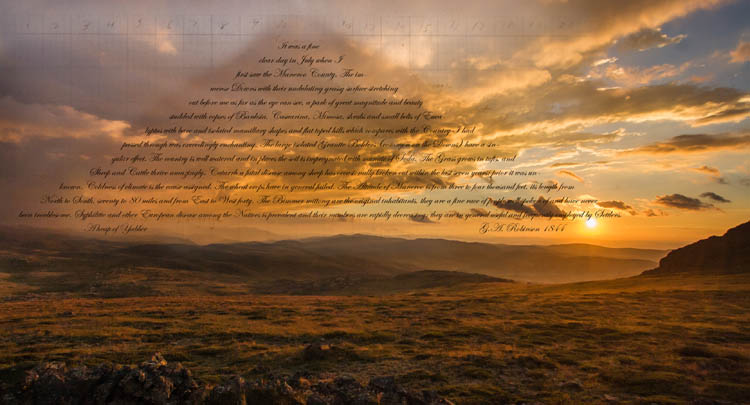
From 1839-49, he was ‘Chief Protector of Aborigines’ for the Port Phillip District, during the course of which time he travelled widely, including an 1844 journey up through Gippsland and across the Monaro. The text in this image is an extract from his official report on those travels. In it he records that:

It was a fine clear day in July when I first saw the Maneroo County. The immense Downs with their undulating grassy surface stretching out before me as far as the eye can see, a park of great magnitude and beauty studded with copses of Banksia, Casuarina, Mimosa, shrubs and small belts of Eucalyptus with bare and isolated mamillary shapes and flat toped hills which compares with the Country I had passed through was exceedingly enchanting. The large isolated Granite Bolders (common on the Downs) have a singular effect. The country is well watered and in places the soil is impregnated with munate of Soda. The Grass grows in tufts, and Sheep and Cattle thrive amazingly. Catarrh a fatal disease among sheep has occasionally broken out within the last seven years; prior it was unknown. Coldness of climate is the cause assigned. The wheat crops have in general failed. The Altitude of Maneroo is from three to four thousand feet, its length from North to South, seventy to 80 miles and from East to West forty. The Bimmer mittong are the original inhabitants, they are a fine race of people well spoken of and have never been troublesome. Syphilitic and other European disease among the Natives is prevalent and their numbers are rapidly decreasing: they are in general useful and frequently employed by Settlers.

The American artist Robert Smithson (1938-73) is most well known for his ‘land art’, and for his critical and theoretical writings. In the course this he produced his pencil drawing A Heap of Language (1966), a work of ‘language to be looked at’.

Robert Smithson. A Heap of Language (1966)

Robert Smithson. A Heap of Language (1966)

Because I’ve recently been researching both Robinson and Smithson, it seemed somehow logical to connect the two in this image. In the process Smithson’s ‘Pile of Language’ has become ‘A Pile of Yabber’, forming a new mountain amongst the rolling hills south of Jagungal.

All the cracks had gathered

All the cracks had gathered

All the cracks had gathered Click to view larger image

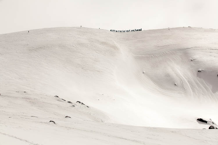
Since its publication in The Bulletin in April 1890, Banjo Paterson’s The Man From Snowy River  has come to exemplify the kind of bravery and bush skills that Australians like to identify with – even though relatively few have ever lived the kind of bush idyll depicted in the poem. Although one of the most urbanised nations in the world, the image of the rough, resourceful and resilient ‘bushie’ has always been a core part of the national identity.

Few poems have been as well known and popular, and the first verse is probably known by more Australians than any other ‘local’ poetry:

There was movement at the station, for the word had passed around
That the colt from old Regret had got away,
And had joined the wild bush horses – he was worth a thousand pound,
So all the cracks had gathered to the fray.

For many people it’s also been considered to be a story about and set in the ‘High Country’, though apparently Paterson was thinking of the country around present-day Burrinjuck Dam when he wrote it. (Perhaps this should be obvious, as ‘the man from Snowy River’ was an outsider in the poem.

In this image, I’ve taken a couple of liberties with Banjo’s poem. Firstly, favouring popular misconception over geographical accuracy, I’ve set a fragment of the text into the Snowy Mountains, at the summit ridge of Mt Twynam (second only to Kosciuszko in altitude), seen from the northeast side near Little Twynam. And secondly, the ‘cracks’ are not mounted on horseback but on cross-country skis as they near the summit.

Watson’s Crags

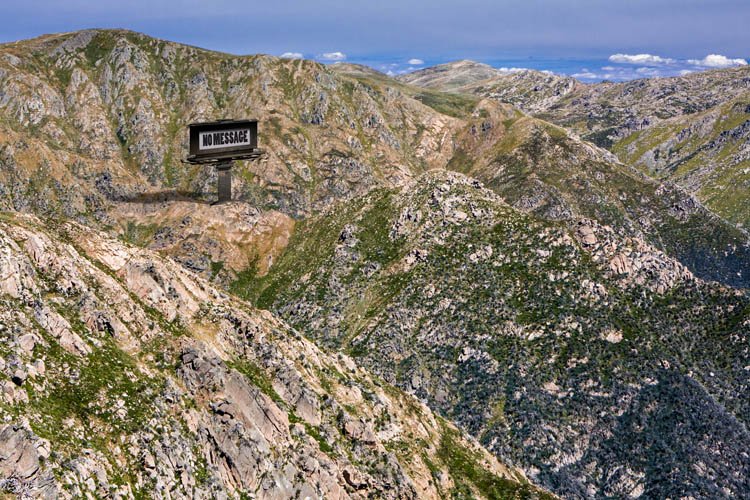
Watson's Crags - No message

Watson’s Crags – No message Click to view larger image

Watson’s Crags lie on the steep western side of the Kosciuszko Main Range, between Mt Twynam and Mt Townsend.

It’s a rugged and rarely visited part of the mountains, several hours walking or skiing from the nearest road or ski-lift access. In Winter some intrepid skiers brave the steep slopes, and in summer a very occasional bushwalker, but mostly it’s left undisturbed by humans. Unlike much of the region, people have made no claim to the land, don’t try to ‘make use of it’, and are content to just let it ‘be’.

So if this land could speak, I imagine that it would talk with its own voice, unsullied by any accretions of human aspiration or ambition. In this image, a massive billboard has been constructed to allow the land to speak to us with its own voice, and its message is…. “No Message”.

This image relates to an earlier “No message” billboard, this time sited on the other side of Mt Townsend. Click here to view it.

Wilderness

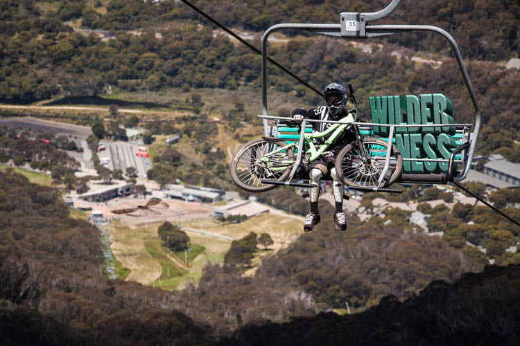
Wilderness

Wilderness Click to view larger image

What we now refer to as “The Snowy Mountains” region was once, and for tens of thousands of years, the exclusive domain of indigenous people. In particular it was home to the Ngarigo, but was also visited for seasonal feasting on the Bogong Moths by people of the Ngunnawal, Wiradjuri, Jaimathang, and Walgalu (and perhaps other more distant groups also).

Now the area is used for a range of purposes, which are often in competition or open conflict over their respective claims to the land. It is a place of wilderness parkland, winter skiing and summer bike riding, heritage and commercial development, irrigation storage and hydro-electricity generation, pastoralists and tourists, all alongside each other. The land is marked by evidence of their various pursuits – pipes and dams, ski lifts and feral pigs (and horses and rabbits etc), fences and fire trails, mountain huts and luxury resorts.

In this image, looking down to Thredbo Village from near the top of the Crackenback chairlift, adventure sport and wilderness are placed side-by-side, metaphorically sharing the same lift up the mountain. Down below, at the out-of-focus resort, a giant Bogong Moth rests on the ground as if on a helicopter landing site.

Snow leases

Snow leases

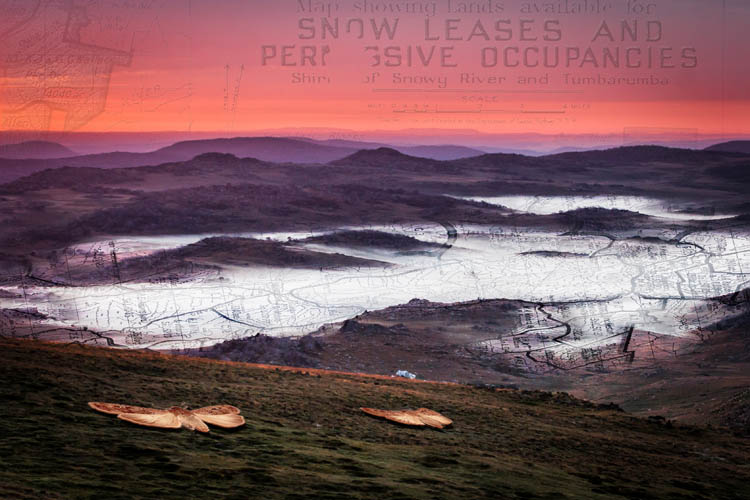
Snow leases (Click to view larger image)

The area around Mt Jagungal is now a designated wilderness zone within the larger Kosciuszko National Park. According to the Environmental Defender’s Office, “Wilderness areas are usually large, remote and undisturbed areas, generally unchanged by humans and their works or areas that are capable of being restored to such a state.”  No construction, commerce, vehicles, hunting, etc is permitted.

But the land still bears traces of previous human activity. For those who know where and how to look, there is evidence of the visits by indigenous people from several surrounding language groups. They called Jagungal “The Big Bogong” because of the masses of Bogong Moths that were consumed there during summer months.

The area was later used for summer grazing of stock, with many thousands of animals (mostly sheep) brought up to the ‘High Country’ from the surrounding lowland farms, and even stock sent on agistment from properties in distant western New South Wales. The land was allocated through auction of ‘Snow Leases’ to individual farmers and pastoral companies, from around the 1890s through to the 1940s (and ’50s in some areas). Through this period, from late November until about March (depending on the arrival of the first snows), the region was filled with the stock and stockmen who looked over them.

The evidence of those times is still visible in the small number of huts which are still maintained as emergency shelters and/or cultural heritage, and the many which are not maintained, and now collapsing and slowly returning to the soil.

Fenceposts, decaying stockyards, overgrown tracks (with some maintained as fire trails), culverts, chimney stones, bits of tin and wire, even broken bedframes and rum bottles can still be seen at many places, though blending back into the ‘wilderness’ a little more with each season.

This photo was taken at 5:29am on 3 February 2008, when I was camped just below the rocks of the Jagungal summit. The aspect is down to the southwest, with early fog starting to lift from the frost hollows below. The overlays show detail from a 1940s snow lease map of the area.

Farm Ridge/Bogong

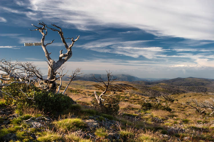
Farm Ridge tree

Farm Ridge/Bogong Click to view larger image

The base photograph for this image was recorded along the now-overgrown Farm Ridge Fire Trail, at the top of a climb up from the Tumut River and several kilometres north of the ruins of the Farm Ridge Hut. It looks south along the ridge towards Mt Jagungal and the Main Range in the far distance.

In this image I wanted to allude to the same issue taken up in another image (Doubtful) – the contested nature of place names in the Snowy Mountains region, and the conflicting narratives which lie underneath the various names in competition.

The Aboriginal visitors to this area (which appears to have never had permanent residents) used different names to denote a place, according to their language group, clan membership, level of initiation into sacred knowledge – and even the season. ‘Jagungal’, the name now applied to the largest mountain of the area, is only one of the names transcribed by early European visitors, who also recorded the name as ‘Targil’, ‘Teangal’, ‘Jar-gan-gil’, ‘Corunal’ and ‘Coruncal’. It is no longer possible to know whether the name ‘Jagungal’ would have been understood by the original inhabitants.

It is certain, however, that ‘Bogong’ was widely used to indicate the places where Bogong Moths could be found during the summer months, the high country places with granite boulders that were destinations for seasonal migration and feasting. Jagungal was referred to as “The Big Bogong”, so as to distinguish it from other destinations such as those now known as Dicky Cooper Bogong, Paddy Rush’s Bogong and Grey Mare Bogong.

The ‘Bogong’ name referred not only to the peak, but also to the surrounding region. The name identified not just a place – but the function and value of the place as well i.e. as country where Bogong Moths may be had.

The European pastoralists who commenced their own seasonal visits to the region in the second half of the 19th century demanded a more precise and detailed set of names for the topographic features and localities of the area, and set about putting their own names onto the landscape. For them, this naming of places was connected with the assertion of ownership; if I know names for all the places in a region, especially if I have myself given them names, then my claim to a legitimate and proprietorial relationship with the place is strengthened.

Like the original inhabitants, the mountain stockmen frequently adopted place names which referred to some story associated with the place (e.g. ‘Pugilistic Creek’) or to the function or value of the area. ‘Farm Ridge’, which runs north from near the foot of Mt Jagungal along the Tumut River, is a name which clearly denotes the area as a place for white Australian agriculture – and no longer as a place for feasting on the Bogong moth. (Though, interestingly, the mountain stockmen who visited and worked in this area up until about 60 years ago would still refer to Jagungal as “The Big Bogong”.

In this Farm Ridge/Bogong image, I have tried to juxtapose these two opposing visions of the mountain scene. The ‘Bogong’ name is depicted as tied more closely to the landscape (through thousands of years of use), with the ‘Farm Ridge’ name tacked on (or suspended from a tree branch) in a more fragile way, reflecting a shallower connection to the land. One interpretation could be that the country ‘knows itself’ as Bogong, but has not (yet) come to identify itself as Farm Ridge.

The interesting thing about both names however (common to many place names) is that neither name reflects the actual current human use of the land. No-one comes to harvest the summer Bogong moths any more, and summer grazing of stock in this region, now designated as the ‘Jagungal Wilderness’ within the Kosciuszko National Park, was stopped decades ago.

However the Bogong Moths still come every summer.